

|

|

|

|

|

|

|
||||||
Residential Boundary Surveys |
||||||||||||||||||||||||||||||||||||||
Residential boundary surveys, often called boundary surveys, are among the most common surveys and most likely to be encountered by the general public. Residential land surveying involves the precise measurements of the boundaries of a certain piece of real estate. Boundary surveys may be used in the case of property disputes or before you build on the land. Title and lending companies may also require a boundary survey showing structures on the property. Residential land surveying is much more complicated than simply measuring the boundaries of your land according to the property deed. Land surveyors actually research and then plot the true boundaries of the property. One step that is often forgotten about by those considering a survey of their land is the research that begins before the actual measurements may be taken. The first step of a land survey is to search for any records concerning the property. These include title certificates, deeds, and other papers. Then, the land surveyor researches past surveys, easements, and other records which may influence his findings. Most of todays homes are built on property that was sold after dividing up a larger piece of property; this can make the surveyors job more challenging, especially if this division was not surveyed or recorded properly. Once the surveyor understands the historic boundaries of the property, the land surveyor will take the measurements of your land, determining whether the in-use boundaries conflict with the adjoining properties, boundaries recorded in public records or past surveys. Various points are marked, usually using iron pipes or rods, to make re-surveying the land easier at some point in the future. The measurements may be taken using a transit and tape measure, or an electronic instrument known as a total station with a built-in electronic distance measuring devise. Today, GPS may also be used for land surveys, though not usually in areas that are heavily wooded. Newer technology is allowing residential land surveying to be undertaken with very accurate results. Usually, a land surveyor will measure each location multiple times, averaging these results to determine the true position of the point. The location of boundaries and easements will then be marked on your land. After the measurements are complete and have been marked on your land, the land surveyor will generally walk the property with you, pointing out the landmarks measuring each point, such as a plastic or metal stake. Then, the surveyor will advise you on any differences between the current survey and previous surveys or records of the land, including any areas where neighboring property owners have encroached on the land. Usually boundary lines do not differ significantly from the previously accepted land boundaries, but this is not always the case. In some situations, your neighbors will also need to have a boundary survey conducted if there is a boundary dispute. Having your property surveyed by a professional land surveyor can give you peace of mind as you gain certainty about the exact boundaries of your property. |
Why do I need a boundary survey before purchasing land? |
|
|
|
If you are interested in purchasing real estate, the wrong way to go about it is to simply find a plot or house that you like, and then make an offer. There are several often-forgotten steps that you should take before this point. Many people often overlook the land survey step of buying land. The best time to have a land survey undertaken is before you complete the process of purchasing the land. Land surveyors can determine the boundary measurements to make sure that the plot of land you think you are buying is actually what you are buying. The land surveyor can tell you whether the trees, building, fences, sidewalks, driveways, and other features of the land actually lie on the property, and also whether anyone elses buildings or other features encroach onto the property you wish to buy. They will also be familiar with building regulations, wetland regulations, and zoning. Land surveys are particularly helpful when purchasing a piece of real estate that you hope to eventually build on, as they can catch potential problems with this plan before you purchase the land. If you are purchasing mountainous land, land that may be considered wetlands, or land in other areas that may be difficult to build on, a land surveyor can help you evaluate the possibilities for building upon the land. If you plan to develop the land or subdivide it, a survey can help you determine whether this is possible or even legal. Do not use an old land survey provided by the current landowner. It may not describe recent changes to the land. The land surveyor you hire can place permanent markers on the corners of your property so that you are well-aware of the boundaries of the land that you will soon own. Before contacting a land surveyor, you may want to ask your real estate agent for a property profile, which will list the ownership information, legal description, plat map, tax information, and other characteristics. This is an excellent place to start when evaluating a potential real estate purchase. At least some of this information may also be available online. Then, be sure that you visit the property and walk the entire site, even if it is several acres, to see what it looks like with your own eyes. Having a land survey conducted before the land changes hands is simply due diligence. Do not rely on anyone elses word, such as the landowners, or a real estate agents, when purchasing land. This is a big purchase, and it should not be done unless you know exactly what you are buying. If you cannot get a land survey before placing a formal offer, at least have one done before the deal closes. The land surveyor will give you the best information possible to determine whether the piece of real estate will meet your needs. If any red flags come up, be sure that they are resolved to your satisfaction before closing on this real estate deal. You do not want to make the mistake of buying land that is of no use to you, or buying land that is not what you thought it was. Although its especially important to have a land survey conducted when you are buying acreage or plan to develop the land, a land survey even of a small lot with a house can still catch potential problems before its too late. |
Planning to Fence your property or add permanent improvements? |
|
|
|
If you are thinking about installing a fence or having someone install a fence for you, contacting a Professional Land Surveyor like Manzie & Drake Land Surveying should be a top priority. Many times a homeowner or fencing contractor will say they "found the pins" and don't need a professional to help out. In some cases this is fine, but if not placed correctly it can lead to major problems and possible lawsuits. Whether you are considering installing a fence, pool, home addition or back yard shed you need to know the limits of your property. A well marked property survey prevents boundary problems from occurring and gives you peace of mind about your biggest investment your home. |
Examples: |
|
|
|
Click the following image for an example of a residential boundary survey performed by Manzie & Drake Land Surveying. 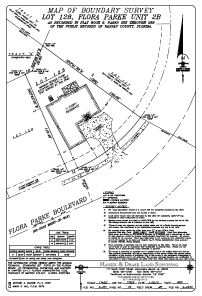 |
| |
|
|
Home | About Us | Scope of Service | Photo Gallery | Why a Survey? | Cost | Clients | Links | Employment Copyright ©2009 Manzie & Drake Land Surveying - All Rights Reserved | ||||||||||||||||||